Card rolls and watches
The first half of the 20th century gave us the first navigators.
The Wrist Navigator appeared on the market in the 1920sPlus Fours Routefinder. This British invention looked like a watch, but instead of the dial and hands there was a map. The work was based on a very simple principle: the cards were rolled up, they had to be scrolled manually. A set of rolls was sold complete with a navigator, they covered the main roads of England. All major intersections were numbered so that it would be easier for the driver to replace the roll if they had to roll somewhere. Also on these maps the distance from one point of the route to another was indicated, and at the end was the word “Stop”.
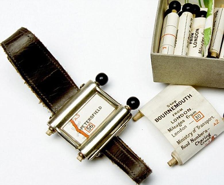
In 1930, supposedly in Italyintroduced the first car navigator Iter Avto. It was necessary to insert a roll with a map of the terrain into the mechanical device. During the trip, it automatically scrolled at a speed proportional to the speed of the car, because the navigator was connected to the speedometer with a special cable. Thanks to this, Iter Avto pretty accurately showed the position of the machine on the ground. If the driver turned off the road, then it was necessary, as in the case of Plus Fours Routefinder, to replace the roll with the map and find the desired intersection on it.
Harbinger of satellite systems: magnets, beacons and transmitters
60–70s car boom launches firstresearch programs: people tried to create a device that can independently detect a car on the ground, as well as analyze the traffic situation and take it into account when creating a route.
In 1966, the American company General Motorsdeveloped a device called DAIR - Driver Aid, Information and Routing (high tech for help, information and navigation for drivers). It, like its mechanical predecessors, also worked without satellites, so it was assumed that magnets would be installed under the pavement every 3–5 miles (5–8 km - “High Tech”). Also, magnets were planned to be installed at all major intersections. DAIR, interacting with these magnets, had to use buzzers and indicator lights to report the approach to turns and obstacles. Punched cards were used as information carriers in the navigator. The gadget warned the driver about speed limits, road signs and road hazards: information about this was displayed on a special screen mounted on the dashboard. DAIR was also equipped with a radiotelephone, with which you could contact the help desk or call for help.
Due to poor scalability, DAIR did notmass device. However, the principles proposed by General Motors engineers - positioning with the help of beacons, communication with special services - formed the basis of modern navigators.
In 1973, the Japanese Agency for Industrial Scienceand technicians proposed to develop a system that would allow to control the density of the car flow by redirecting part of the traffic to bypass the busiest points. Among the many projects proposed for the contest, Toyota's option was chosen - the Comprehensive Automobile Traffic Control System (CACS). He suggested the installation of a control system on the streets of cities and transmitters in cars. All traffic information was collected and processed by computers in a control center. This would provide both one-way and two-way communication, and the system could steer vehicles along the most optimal routes. Information drivers received using special displays and on the radio. The first tests took place in 1975, and in 1977, after more extensive tests, a special commission recognized that the benefits of the system outweighed the costs associated with its installation, but in 1979 the project was still canceled.
The first navigators and the advent of GPS
By the 80s, it became apparent that the use of systemscar navigation, aggregating information at checkpoints and positioning vehicles in space using specially installed beacons, is unprofitable. Such systems required large material investments, did not scale well, and practically did not work outside of cities. Therefore, autonomous navigators again came to the fore.
In 1981, the Japanese company Honda patentedIn the United States, the first commercial car navigation device is the Electro Gyrocator. It used the principle of inertial navigation: a special sensor with gaseous helium determined the direction of movement of the car, like a gyroscope. Electro Gyrocator received information about the start of the movement and about the stop from the gearbox. All data was processed by an analog computer. Included with the device was a set of cards on a transparent film. Before starting the movement, the driver had to select a map, find the starting point of the route on it and insert the film into a special compartment in front of the six-inch kinescope monitor. Moving the car on this screen showed a luminous dot. The device was very expensive, so it did not receive distribution.
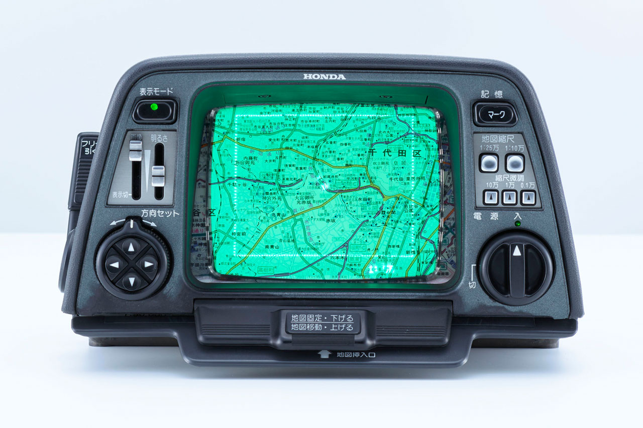 Electro Gyrocator. Photo: Honda
And in 1985 American company Etak introduced itsnavigator. He was able to determine the position of the car with the help of an electronic compass and special sensors attached to non-driving wheels. Digitized cards were stored on cassettes, which could be easily replaced while driving. Information was displayed on a black-green vector screen. The company itself developed all the technical equipment from scratch, and although the project did not become commercially successful, Etak's developments were subsequently actively used in other projects.
A few years before, in 1983, afterafter the Soviet Union shot down the Korean Airlines invading Boeing airspace (the pilots were disoriented), US President Ronald Reagan allowed the use of GPS for civilian purposes around the world. At first, the accuracy of the system for civilian consumers was deliberately reduced, but even this not very accurate positioning affected the further development history of car navigators. In parallel, a search was made for a new media for cards.
So, already in 1987 Toyota launched a navigator on the market, maps to which were recorded on CD. The device was installed on the Toyota Crown model; it was impossible to purchase it separately.
In 1990, Mazda introduced the world’s first GPS navigator. They were equipped with fourth-generation cars Eunos Cosmo. This, like Toyota, had an integrated device.
Toyota by 1992 developed another novelty - a navigator with voice prompts. It was installed on the Toyota Celsior.
In 1994, GPS navigators appeared on the European market. BMW and Phillips present the jointly developed device among the options for the 7-Series in the back of the E38. The navigator is equipped with a color display.
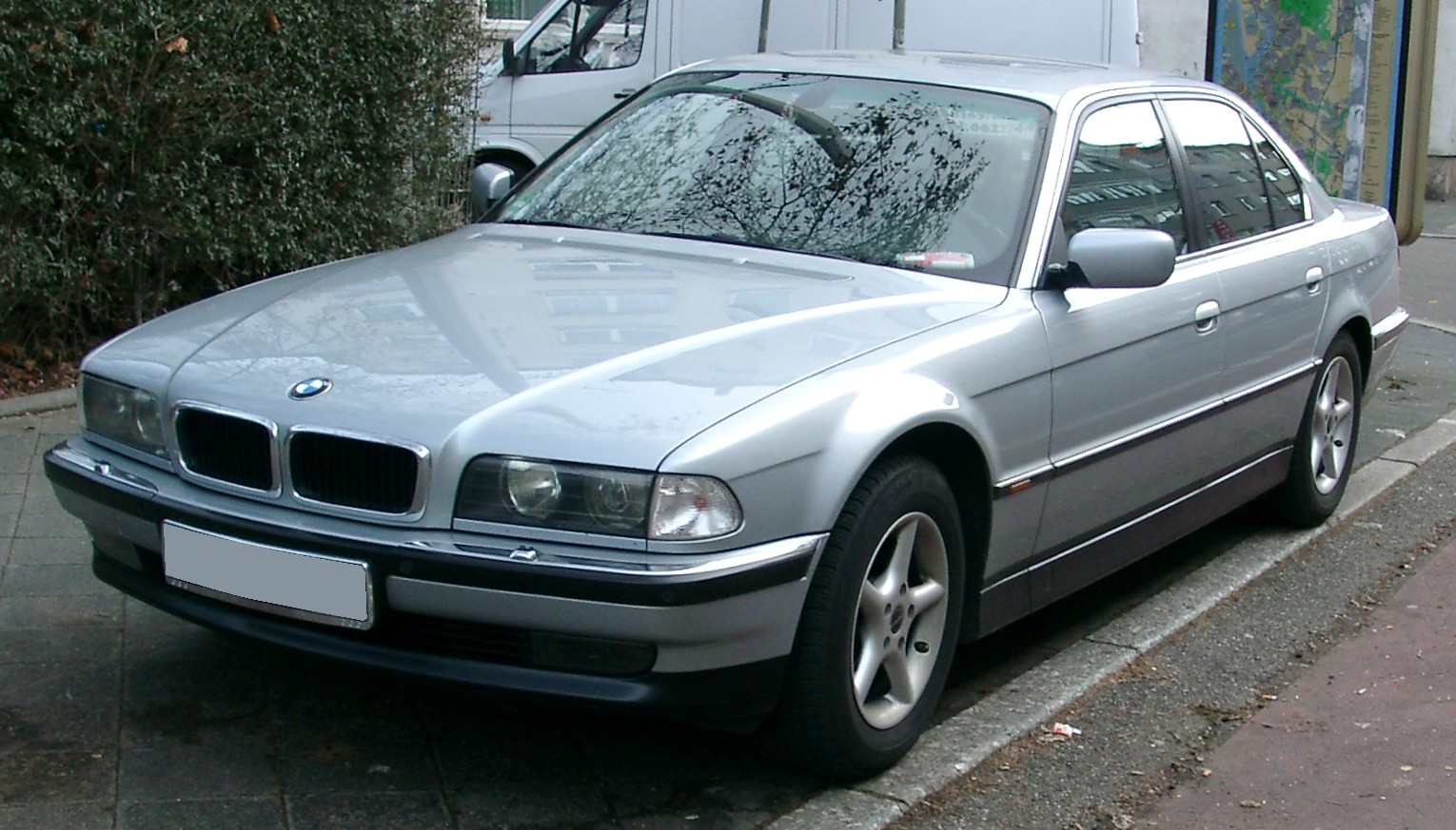 BMW E38 car with the first GPS navigator. Photo: Wiki
A year later, in 1995, GPS navigators entered the American market. A device with the poetic name GuideStar - “Guiding Star” - has been installed on some Oldsmobile models.
In the same year, Japanese Acura introduced a navigator with maps on the hard drive.
Two years later, in 1997, a Japanese companyAlpine introduced its version of the multimedia device Alpine CVA-1005 with built-in GPS-navigator. The device could be installed on any car, and maps to the navigator were recorded on a CD. Each disk, despite the large amount of information stored for that time, covered a small area - for example, only a few states.
In 1998, Garmin launched Street.Pilot, the first portable car navigator with a monochrome screen and preloaded maps. The device could be mounted on a panel or on the windshield. A little later, an improved version appeared - with a color display.
The advent of GLONASS and Google Maps
2000 was remembered by the fact that Bill Clinton canceledrestrictions that apply to the use of GPS for civilian purposes. In the meantime, on the market of navigators, searches continued for the optimal information carrier, as well as additional benefits that would attract customers to the products of a particular manufacturer.
In 2006, navigators go to Russianmarket. The first company to offer these devices for our country was BMW, which released on a CD card in Moscow and Moscow region. True, they were not very detailed, and instead of Russian they used transliteration.
A year later, in 2007, the first civilian navigator appeared on the market, supporting both the American GPS and the Russian GLONASS. It was a Russian Glospace.
Around the same time, Toyota makes an attemptsolve the problem of insufficiently quick update of maps and offers the Japanese market Map on Demand - update maps at the user's request using the home Internet. The Japanese were able to easily and quickly download fresh maps to their devices.
And already in 2008 Toyota introduced the firstnavigation systems related to the braking assistance system and the adaptive suspension. They told the driver when to slow down, based on the data of the cards, and also adjusted the suspension.
The second decade of the 21st century in the field of car navigation has brought new collaborations, as well as attempts to integrate navigators into systems that were not previously associated with them.
So, in 2011, Audi introduceda navigation module with Google maps that were downloaded from the Internet. Drivers have the opportunity to choose a way to present information on the display. They were no longer limited to a schematic representation of the area.
In 2013, Mercedes-Benz announcedconcluding an agreement with Garmin. Together they developed a navigation system that is fully integrated into the car’s infotainment module. The first was the dual-display Garmin on-board system with three-dimensional maps. It was installed in the S-Class Coupe. And in the CLA Coupe, Garmin’s Vivoactive smartwatch could be connected to the navigation system, they constantly monitored the driver’s pulse and assessed his condition.
These developments allowed Mercedes-Benz in 2019.to introduce the ENERGIZING comfort management function in the year: with the help of music, light and other systems responsible for comfort in the car, it improves the ride quality. And if you connect a Mercedes-Benz Vívoactive 3 watch or another compatible Garmin device to this system, then ENERGIZING will tell you which program is better to choose by evaluating the driver’s personal indicators, such as stress level or sleep quality.
Jaguar introduced the system in 2014augmented reality Follow-me Ghost Car Navigation, which projects various information necessary for the driver onto the windshield, as well as the silhouette of a “ghost car” - it shows where to go. It is enough for the driver to follow her to get to the destination.
Experts believe that the creators of navigation systemstry to create drones. And when technology takes over the management, the development of navigators will enter a new round: in these systems the quantity and quality of infotainment functions will increase.
According to PWC consultants, by 2021the infotainment segment will become the third in potential - after ensuring safety and supporting autonomous driving - with an estimated volume of 13.4 billion euros. Most likely, with the development of unmanned technologies, solutions in the field of connected cars and navigation will become more diverse. Are expert forecasts correct? We will find out very soon.