Make a map of the area without human help, count saigas, and then dive into the water and not get lost,
Drones track the population of rare animals
Today, drones are used to monitorthe population of Far Eastern storks that live in the Bologna Nature Reserve and in the Aistin Nature Reserve: both are located in the Khabarovsk Territory. Drones are also used to count saigas in the Stepnoy reserve in the Astrakhan region, as well as to find out the number of walruses in Chukotka.
Over the past few years, drones have been used in Russiaare beginning to be used to track the population of rare species. It is more convenient to observe animals using drones, since this method is cheaper than satellites, and it also does not create as much noise compared to helicopters. In the case of the latter monitoring method, animals can simply run away from fear and disrupt all plans.
But drones also have a minus - insufficientBattery capacity. To prevent the copter from running out of charge on the fly, reserve staff create, for example, special networks of charging complexes or specially improve the components and algorithms for controlling the device.
Create a map using information from the drone
Drones help surveyors conduct ground surveysresearch. For example, previously, to create a map of an area, it was necessary to use total stations (instruments for measuring distances), GPS devices and terrestrial laser scanners, with which you can obtain high-resolution information about the space.
Now there are copters that can be equipped with digital high-precision cameras, as well as geopositioning modules and hardware software to improve the quality of the results.
Drones are being used to create digital3D terrain models, photographic diagrams and orthophotomaps using aerial photography. The latter is a digitally transformed image of the area created from overlapping original photographs. Photogrammetry is also used to create maps - this is when several photographs taken at the same point are combined and processed together. The result is a map.
Also, in the wake of active work with drones, we begandifferent projects appear that can autonomously create a map of the area and independently process it. One of them is Maps Made Easy. This is software that connects different images into a common map. The cloud-based system adjusts photos to appear from the same angle. You can also pinpoint GPS coordinates to create a georeferenced map.
What drones report about seasonal and climate changes
In addition to observing individual parameters,drones can give us a big picture of how the area is changing. For example, this is how employees of the Brookhaven National Laboratory collected information: they made a three-dimensional visualization of the surface topography and structure of the vegetation cover of the Arctic using drones.
The authors respond that satellites are usually used for the same purposes, but their images have low resolution, so small-scale models cannot be created in this way.
This problem particularly affected researchersArctic, since this area has mixed vegetation. So scientists decided to try an unmanned aerial vehicle (UAV) to gather information about changes in the area.
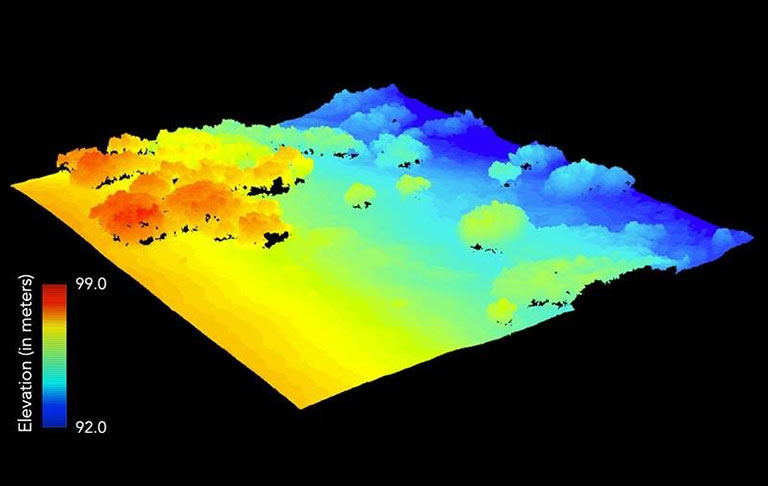
The authors of the work managed to create a three-dimensionalvisualization of the Arctic. They emphasized that drones are much easier to operate in remote areas than other airborne systems. Also, these devices can accumulate information on demand in various conditions.
Do it all the same, only underwater
To ensure remote monitoring even underwater, scientists decided to create underwater drones. Such devices have completely different complexities and problems. First, radio signals do not travel far into the water column, and it is also difficult to create an underwater control system and maintain buoyancy.
Therefore, experts began to make their models either fully autonomous control or a special timer, which after a certain time automatically returns the drone to the surface.
For example, in this work, the company has advancedElwave - She studied the sense organs that fish use to move underwater, we are talking about the electric sense of smell - this is a way of perception used by tropical fish living in muddy and heavily contaminated waters, where normal senses are ineffective.
Based on this information, the employees decidedto create special systems for underwater drones that will allow them to work in troubled waters. The system can detect and localize objects in 360 ° and in real time for underwater and industrial robots. It works on both remote-controlled (ROV, ROTV) and autonomous drones.
Drones are a convenient alternative for working onheight or depth. These systems have become so universal that they are beginning to be used not only on Earth, but also in space. Now scientists can find out all the information remotely without putting anyone in danger. Today, preparations are already underway for the next space missions with UAVs in the lead role.
Read more:
NASA has released images from Mars. Users compared one place to a cemetery
Life on Mercury, closer to the Sun: a very bad or brilliant idea
Impossible to imagine: what are the largest objects in the universe and where they are