In July 1972, NASA launched a new Earth imaging satellite, the Earth Resources Technology Satellite (ERTS). This
How did it all start?
The first two satellites operated at fourspectral ranges, or wavelengths of light: visible light in red and green, and two near-infrared ranges. The near-infrared range allowed satellites to distinguish vegetation from other land cover and assess the condition of the flora. In turn, visible wavelengths distinguished bright surfaces such as snow, deserts and clouds from dark surfaces such as water. Each stage covered 185 km on one side.
 The first full Landsat image taken on July 25, 1972. Photo: NASA Earth Observatory
Data from the first satellites was recordedon huge magnetic tapes. The bulky wideband video recorders that flew on the first three satellites weighed 34 kg each. The ribbons on them were almost 550 m in length.
Based on these data, scientists generatedand printed photographic images. These images provided a bird's eye view of the area. However, the real power of this data became apparent as computer algorithms helped researchers more effectively identify land cover categories.
How many images were made by Landsat satellites?
Since its debut, Landsat has collected more than 10million images or scenes. These photos show more than just real-time shots of land and coasts. Combined with images from yesteryear, they capture changes over time – slowly disappearing glaciers or urban spaces sprawling across the landscape.


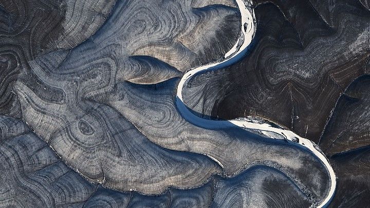


The best Landsat images. Photo: NASA Earth Observatory
What are they needed for?
These scenes and comparison images applyaround the world. So, hydrologists use them to track the change of rivers; environmentalists to determine the extent of deforestation; farmers and agricultural organizations - to analyze the state of crops.
In the five decades of Landsat's existence, eightvarious Landsat satellites circled the planet. Now three satellites continue to collect global observations from space: Landsat 7, 8 and 9 (Landsat 6 was lost shortly after launch). Landsat 9, the newest of the series, entered orbit in the fall of 2021. In some ways, it is similar to its predecessors, but the design of the last satellite has changed a lot since the inception of the program.
What's next?
As Landsat continuestransform, the people and projects that use it are also growing. Scientists and engineers are already looking forward to the next mission, and for good reason: NASA and the USGS are developing options for the next iteration of Landsat, currently called Landsat Next.
 An artist's impression of Landsat 9, the ninth satellite launched as part of the long-running Landsat program, high above the United States. Photo: NASA
According to scientists, Landsat space observationsprovided new opportunities for understanding a changing planet. “We can’t all be astronauts. But by looking at Landsat images, anyone can understand what the Earth looks like from space. This is a unique opportunity,” the scientists conclude.
Read more:
A compelling new theory emerges as to why the Mayan civilization collapsed
The supersonic plane will fly at a speed of 2,000 km/h and cross the ocean in 3.5 hours
Archaeologist robot dives 1,000 meters underwater to inspect sunken ship