A photograph taken by the High Resolution Stereo Camera (HRSC) on the Mars Express orbiter shows parts of
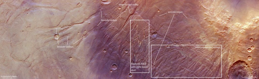
Scientists believe that the plateau is formed asdeformation of the planetary crust, and water flows in the past. Although Mars no longer shows signs of active tectonics, this was not always the case. It also caused surface cracks, known today as Nectaris Fossae. They are visible as almost vertical scars in the center of the image and have since been filled with light dust.
 Mars area map. Credit: European Space Agency
Also in the photo you can see Protva Valles. These "valleys" formed when there was much more water on the surface of Mars, about 3.8 billion years ago, and have remained virtually unchanged since then.
 Topography of Nectaris Fossae and Protva Valles. The terrain resolution is approximately 23 m/pixel, one of the highest to date. Credit: European Space Agency
"Mars Express" - operating automaticinterplanetary station of the European Space Agency designed to study Mars. The spacecraft consisted of an orbital station - an artificial satellite of Mars - and a descent vehicle with an automatic Martian station, Beagle 2.
Read more:
Scientists have named the top 6 ways to "save" the memory of older people
A mysterious imprint underground surprised scientists. He is over 1000 years old
Sword thought to be fake turns out to be a 3,000-year-old Bronze Age artifact
Full resolution photo - on the ESA website